
Ham Harbour and Mill
21st July 2015
Over the years we have visited Ham to see the Harbour and the Mill. This time a camera suspended beneath a kite gave us a few views from above. The other more conventional views show that little has changed over the years apart from the gradual disintegration of the harbour with the flagstones scattered around.
Ham Harbour - G Watson - Published in Caithness Field Club Bulletin
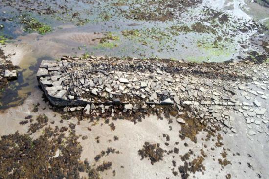
The persistent action of the sea is inevitably taking its toll of Ham harbour, which has not been used or maintained for many years. The attached sketch,( Not Available at time of publication on Caithness.org) made last year, shows the outline of the original structure which can just be made out under the rubble.
The inlet was first mentioned by MacFarlane, c1725, as a place used by small trading vessels. Moll's map of the same date carried a note "Ham Ferry to Snelsetter (probably Melsetter) in Hoy Island". In 1700 Captain James Moodie of Melsetter owned the public ferry between Brims on Hoy and Rattar in Caithness. It seems that the boat would land at Ham or Scarfskerry whichever was most convenient. In 1818 William Daniell made the trip from Scarfskerry to Melsetter taking three hours for the crossing and paying 15/- for the hire of the boat and crew. To assist seamen, Alexander Bryce re-mapped the coastline of northern Scotland in 1744 and Ham is one of the many havens named. By 1791 the first improvements to the natural inlet were described in the Old Statistical Account for Dunnet which records :-
"It (Ham) might also be rendered safe for small vessels, at little expense. There is a superficial pier erected there already; and the ground within it being pretty well cleared of stones, vessels of or below 100 tons, find no inconveniency of loading or unloading a cargo, or even lying there for weeks in the summer season. It has, however, the inconveniency of a bar, or ridge of sand and gravel, across the entrance of it, upon which there is not sufficient depth of water for vessels in any great burden, but with spring tides".
The superficial pier was probably built by Rattar estate to export grain from their storage girnal which dominates the head of the inlet. This building was later converted into a corn mill and is now used to garage farm machinery.
James Traill, of Castlehill, acquired Rattar from his sister-in-law and by good management turned a debt ridden estate into a going concern. He was also involved with the improvement of his other estate at Castlehill. By 1824 he had explored the possibility of exporting flagstone to the growing cities in the south and as a result opened up Castlehill quarry on an industrial scale. Initially the flagstone was shipped from the estate harbour at Castlehill but this proved inadequate for the growing output of flagstone and about 1830 he had a another harbour built at Ham.
James Bremner designed and supervised the building of both harbours. John Mowat in his excellent booklet on Bremner (p10) say that "He also built the harbours of Castlehill, Ham and Sandside in Caithness, using the same method of securing the entrance with boom gates to allow excavations." The vertical slots for the dam boards are very evident at Sandside and Castlehill where the boards continued to be used during the working life of the harbours. They enabled ships, which had been loaded after settling on the bottom at low tide, to be gently refloated even in rough weather. The harbour at Ham is now quite ruined but the lower section of both sides of the entrance are intact and do not have vertical slots. Dam-boards may have been used at Ham during construction, but unlike Castlehill and Reay, they did not feature in its day to day operation. It is noticeable that the entrance at Ham is less exposed and any large waves entering the inlet are more likely to spend their energy on the beach without entering the harbour basin. The ruined harbour is an interesting place to visit as many of the details of its construction have been revealed in the sections of wall which still stand.
Towards the cliff can be found traces of the original quarry which provided many of the huge stones.
Description of the Mill from Buildings At Risk Web site -
See http://www.buildingsatrisk.org.uk/search/planning_authority/190/p/3/event_id/914000/building_name/ham-mill-dunnet
Early to mid 18th century girnal; mid 19th century conversion to water-powered corn mill, and later alterations. Large 4-storey, 5-bay agricultural building (former girnal) built against north facing slope presenting 3-storey appearance to S elevation. All Caithness flagstone rubble with tooled rubble dressings. N (PRINCIPAL) ELEVATION: paired fenestration to outer bays; off-centre vehicular opening (20th century alteration) to ground with further doorway to left. Rear (S) elevation: central timber doorway to 2nd floor approached by forestair; segmental headed wide entrance to left. No water wheel, lade or other external machinery. INTERIOR: no internal floors. No internal machinery. Remains of 20th century concrete grain dryer to ground. Some evidence of earlier flagstone floor. Timber joists. Caithness slate roof. Square-plan, mid 19th century kiln addition (roofless) adjoins to SW.
The former girnal and water-powered grain mill at Ham is an important example of its agricultural building type in Caithness. Having undergone a number of interrelated changes of use, the building is notable for its scale and it continues to reflect the historic importance of the grain trade to the economy of the area. Prominently sited within its rugged coastal setting it is also notable for its Caithness flagstone construction. The location of the building appears to correlate with a building depicted on Roy's map of 1747-51, possibly dating the first phase of its construction to the early half of the 18th century. (Historic Scotland)
OS Grid Ref ND 23910 73555
Search Our Site
Information
What's On
Submissions